


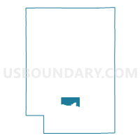
PINE VALLEY - T 1 Voting District, Clark County, Wisconsin
About
Outline

Summary
| Unique Area Identifier | 692775 |
| Name | PINE VALLEY - T 1 Voting District |
| County | Clark County |
| State | Wisconsin |
| Area (square miles) | 13.60 |
| Land Area (square miles) | 13.47 |
| Water Area (square miles) | 0.13 |
| % of Land Area | 99.02 |
| % of Water Area | 0.98 |
| Latitude of the Internal Point | 44.57794240 |
| Longtitude of the Internal Point | -90.62297330 |
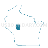
Maps

Graphs
Select a template below for downloading or customizing gragh for PINE VALLEY - T 1 Voting District, Clark County, Wisconsin


Neighbors
Neighoring Voting District (by Name) Neighboring Voting District on the Map
- GRANT - T 1 Voting District, Clark County, WI
- GRANT - T 2 Voting District, Clark County, WI
- HEWETT - T 1 Voting District, Clark County, WI
- HEWETT - T 2 Voting District, Clark County, WI
- Neillsville - C 1 Voting District, Clark County, WI
- Neillsville - C 2 Voting District, Clark County, WI
- Neillsville - C 4 Voting District, Clark County, WI
- Neillsville - C 5 Voting District, Clark County, WI
- PINE VALLEY - T 2 Voting District, Clark County, WI
- SEIF - T 1 Voting District, Clark County, WI
- WESTON - T 1 Voting District, Clark County, WI
- WESTON - T 2 Voting District, Clark County, WI
- YORK - T 1 Voting District, Clark County, WI
Top 10 Neighboring County Subdivision (by Population) Neighboring County Subdivision on the Map
- Neillsville city, Clark County, WI (2,463)
- Pine Valley town, Clark County, WI (1,157)
- Grant town, Clark County, WI (916)
- York town, Clark County, WI (886)
- Weston town, Clark County, WI (699)
- Hewett town, Clark County, WI (293)
- Seif town, Clark County, WI (172)
Top 10 Neighboring Place (by Population) Neighboring Place on the Map
Top 10 Neighboring Unified School District (by Population) Neighboring Unified School District on the Map
Top 10 Neighboring State Legislative District Lower Chamber (by Population) Neighboring State Legislative District Lower Chamber on the Map
Top 10 Neighboring State Legislative District Upper Chamber (by Population) Neighboring State Legislative District Upper Chamber on the Map
Top 10 Neighboring 111th Congressional District (by Population) Neighboring 111th Congressional District on the Map
Top 10 Neighboring Census Tract (by Population) Neighboring Census Tract on the Map
- Census Tract 9506, Clark County, WI (4,797)
- Census Tract 9507, Clark County, WI (3,635)
- Census Tract 9508, Clark County, WI (3,173)